Archive for January 26th, 2008

26
Jan
08

Fort San Antonio Abad • Manila

The fort has it origins in 1584, when a structure was built to guard the route between Cavite and Manila, and as a rear guard for the city. The fort was used as gunpowder storage when it was deemed that the Polverin near the Bastion de San Diego in Intramuros posed danger should its content be inadvertently ignited. The British occupied the fort in 1762 and used it in the assault against Manila. On 13 Aug 1898, the American flag flew over the fort, the first time it was unfurled on Philippine soil. Photographs from this era show that the fort had been damaged by bombardment during the Battle of Manila Bay.

Used by the Japanese during World War II, they built a cement shelter or bunker inside and mounted a canon on the bastion. This triangular fort with two bastions was restored, with the construction in the 1970s of a new Central Bank Complex along Roxas Blvd. The fort located between the Central Bank building and the Metropolitan Museum of Manila, serves as a venue for receptions sponsored by the Central Bank of the museum. A wooden image of the fort’s patron San Antonio is found in a niche along the rear wall.

26
Jan
08

Fort Santiago • Manila

santiago-copy.gif

Gate of Fort Santiago

Fort Santiago’s site was formerly occupied by a palisade built by the Muslim ruler of Manila, Rajah Sulayman, who was related to the sultans of Borneo.  Sulayman ruled over the Tagalog, the indigenous peoples that lived along Manila Bay.  Sulayman was related to other rulers who lived north of the Pasig, namely Lakandula or Lacandola and Rajah Matanda. Legazpi’s conquest of Manila in 1571 forced the Tagalogs to relocate to the northern banks of the Pasig River. Sulayman’s fortification was strategic as it controlled access to the Pasig whose headwaters is Laguna de Ba-i, situated east of Manila. This largest lake in Luzon was dotted with villages of the Tagalogs, who were trading actively with Chinese merchants before the coming of the Spaniards.

On 19 May 1571, Miguel Lopez de Legazpi and his troops occupied Rajah Sulayman’s village. They took over the palisade (kuta) in which the Rajah’s residence was built.  That year, on 24 June, Manila was constituted a city of the Spanish realm, formalizing the occupation of the city.  Temporary fortifications at the site of Sulayman’s palisade began as soon as the Spanish took charge of the settlement.  In 1591, construction of the fort in stone began under Gov. Gen. Perez de Dasmariñas. Work on the fortification continued off and on until the 18th century.  By the early 18th century, Santiago had been effectively cut off from the rest of Manila with the construction of a moat before its principal gate. Manila Bay’s safe harbor and the location of Sulayman’s fort, now overrun by the Spaniards, was an excellent nucleus for the creation of entrepôt that catered to the China trade.

Jose Rizal, the national hero of the Philippines, was incarcerated in one of the barracks of Santiago on the last week of December 1896.  He was executed 30 December.  His death sparked the revolution of independence against Spain.  Santiago was the site of much bloodshed during World War II. Subsequent reclamation in the early 20th century has pushed the shore further west, some 500 meters. The fort was damaged greatly in February 1945 and was the prison for many prominent Filipinos.  The fort, restored, is a national shrine.  In it is a restored building which houses the Rizal Shrine.  A ruined barrack is now Rajah Sulayman theater. 

26
Jan
08

Watchtowers and fortifications of southern Cebu

Over a stretch of about 95 kilometers—from Carcar to the north to Samboan to the south—a string of watchtowers and fortifications were built in the early 19th century (1802-1815). A good number of these fortifications were constructed at the initiative of Fray Julian Bermejo, an Augustinian, who was assigned to the town of Boljoon and later became the provincial superior of the Augustinians. Fray Julian’s first move was to rebuild Boljoon, which was devastated by a seaborne attack in the 1790s. Fray Julian fortified Boljoon, built a watchtower on a hill beside the church. This watchtower was the lynchpin in Fray Julian’s ingenious warning system. From Boljoon, Fray Julian added coastal watchtowers that would deliver a warning should raiders be seen approaching a town. 

HHe also organized an armada of native vessels, manned by a volunteer militia drawn from the townspeople. Fray Julian’s armada scoured a decisive victory over the raiders off Sumilon Island in 1815. From then on, south Cebu was free from attacks. Fray Julian’s successors added more watchtowers to his system.

A number of these watchtowers still survive in different degrees of degradation. Almost all are abandoned and some are overgrown with vegetation 

26
Jan
08

Intramuros: The Walled City of Manila

Parian Gate Parian Gate 

Pre-colonial Period

Before 1570: A settlement of Tagalog under Rajah Sulayman occupies a tongue of land at the mouth of the Pasig River. Sulayman was Muslim related to the rajahs of Brunei.


Spanish Colonization: 1565-1898

Establishment of Spanish Rule (1565-1600)

1565: Miguel Lopez de Legazpi establishes a Spanish colony in Cebu. A ship under Martin de Goiti returns to Spain with a cargo of cinnamon; the possibility of opening between the Philippines and Spain is explored.

1569:  In search of better food supply, Legazpi transfers the colonists to Panay.

1570:

8 May Spanish soldiers under Martin de Goiti sail from Panay to reconnoiter Manila Bay. The troop assaults Sulayman’s fortification and captures it for Spain.

1571:

April The Spaniards under Legazpi leave Panay to take control of Manila.

16 May: The Spanish arrive at Manila Bay.

19 May: Feast of Santa Potenciana (Prudenciana), Legazpi lands in Manila and takes over the fortification and village of Rajah Sulayman. Miguel Lopez de Legazpi transfers the Spanish colony from Panay to Manila. Rajah Sulayman, ruler of Manila, transfers his seat to Tondo. 

24 Jun: Feast of San Juan Bautista, the City of Manila is officially established.

1574:

1 Jun: Philip II confers the city with the title “insigne y siempre leal ciudad de Manila.”

First galleon sent to Mexico loaded with Chinese goods and spices.

Manila is attacked by the Chinese Limahong. Gov. Gen. Guido Lavezares, Legazpi’s successor, fortifies the city for the impending attack.

30 Aug: Spaniards successfully repel the Chinese on the feast of San Andres, who is then named patron of the city.

1578: Franciscan friars arrive in Manila.  They reside for the time being with the Augustinians.

1579: Crown orders the construction of a cathedral in Manila, following the Papal approbation establishing the diocese of Manila, suffragan to Mexico.

1581: First bishop of Manila, Domingo de Salazar, OP, arrives in Manila. On board the same ship are three Jesuits assigned to the Philippines. Jesuits reside in Laguio, a site outside the city near present-day Pedro Gil St. and Roxas Blvd.

1583: Bp. Salazar convenes the Synod of Manila to discuss issues and strategies of evangelization and to address complaints about Spanish abuse.

28 Feb: Fire destroys much of the thatched buildings in Manila. The fire begins in San Agustín where the funeral monument to Gov. Gonzalo Ronquillo was set up. First buildings in stone appear after the great fire of 1583. Bp. Salazar and the Jesuit Antonio Sedeño are credited with this initiative.

Jesuits establish a church and house in the city.

Episcopal residence is rebuilt in stone and mortar under the direction of Antonio Sedeño S.J.

The Jesuit Antonio Sedeño builds a stone tower at the southern flank of the city of Manila, facing the hermita of NS de Guia. The tower, later incorporated into the Bastion de San Diego, is named NS de Guia.

1587: Dominicans arrive in Manila.

1591-94: Gov. Gen. Perez de Dasmariñas begins rebuilding Manila’s fortifications in stone.

1593: Dominicans publish catechism in Tagalog, Doctrina Christiana. It is printed by a Chinese in Binondo using woodblocks.

1594: The Hermanidad de la Misericordia establishes the Colegio de Sta. Potenciana for Spanish girls.

1595: Manila is raised to the status of an archdiocese with dependent dioceses Cebu, Naga, Lal-lo under it. Religious orders are assigned specific areas in the Philippines for better management of the evangelization of the native population.

The Jesuits establish the Colegio de San José.

Manila is awarded an official seal consisting of a gold castle and a demilion and dolphin naiant, brandishing a naked sword, against fields of red and blue respectively.


The Dutch Wars (1600-48); Hispanization of lowland communities (1600-50)

1600:

30 August: A devastating earthquake damages Manila.

Dec: Antonio de Morga, oidor of the city of Manila, heads an armada against the invading Dutch ships, under Van Noort. Morga’s ship, San Diego, sinks near Isla de Fortun, in Batangas Bay.

1603: Three Chinese mandarins arrive in Manila to dispense justice among the Chinese. This sparks rumors among the Spaniards of an impending Chinese invasion, and a rumor among the Chinese of a Spanish pre-emptive strike to massacre all the Chinese. This leads to an uprising. As a consequence of quelling the uprising, Chinese forced to live outside of the walled city.

Fire hits the city.

1604: San Agustin church is completed. (Note: Other sources give the date as 1607.)

1605: Government sets control on the galleon trade. Henceforth, all trade would pass through the government, which was in charge of building and outfitting the ship. Private enterprise with Mexico is forbidden.

1606: The Recollects, a reformed branch of the Augustinian order, arrive.

Fire hits Manila again.

1618-29: Under Gov. Gen Alfonso Fajardo de Tenza a moat is built surrounding the city.

1618: The Recollects build a church in Intramuros, after more than a decade where they had a church and residence outside the walls.

1621: The Nuestra Señora de la Paz y Buenviaje is brought by Gov. Niño de Tabora from Mexico and given to the care of the Jesuits, the image becomes the patroness of the galleons.

Second printing of the Doctrina Christiana in Iloko published in San Agustin

1624: Construction of second monastery of San Agustin.

Jesuits establish the Imprenta de la Compañia, in the College of San Ignacio.

1632: The Jesuit church of San Ignacio designed by the Italian Jesuit Gianantonio Campioni is inaugurated.

1635-49: Under Gov. Gen. Hurtado de Corcuera, the moat surrounding Intramuros is improved, deepened and widened.

1639-40: Chinese uprising. Rumors that the Chinese would be summarily executed or deported spreads in the district of Santa Cruz and Mayhaligue. This sparks are revolt which spreads through the rest of southern Luzon.

1645:

30 Nov: Earthquake devastates Manila, many residence and buildings collapse, the walla are damaged, San Agustin loses one bell tower. The beginning of arquitectura mestiza.

1656: The Brothers of St. John of God take charge of a hospital under the patronage of the Misericordia. This hospital traces to the efforts of the Franciscans who had opened in the 16th century a small hospital facing their convent.

1663: Three Dominican tertiaries, led by Mother Francisca del Espiritu Santo established the Beaterio de Sta. Catalina (later becomes the Congregation of St. Catherine of Siena).

1668: The Colegio de San Juan de Letran is transferred to the site it presently occupies.

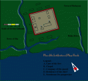
1671: Map of Intramuros by Ignacio Ortiz, O.P. published.


Dynastic change (18th century)

1703: Gaspar Aquino de Belen writes and prints Mahal na Passion ni Jesuchristo na Tola at the Jesuit press in Intramuros.

1711: The Visayan vocabulario by Matheo Sanchez SJ is published.

1727: Mapa topographica of Intramuros and surrounding districts by Antonio Fernández de Roxas published

1734: Map of the Philippines designed by Pedro Murillo Velarde, S.J., and engraved by Nicolas de la Cruz Bagay and Francisco Suarez, published by the Imprenta de la Compañia. Flanking engravings show maps of Intramuros and Cavite.

Death of Mother Ignacia de Santo Espiritu, foundress of the Beaterio de la Companía

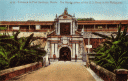
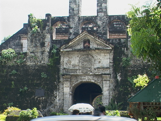
1738-39: Gov. Gen. Fernando Valdez Tamon prepares a thorough report on the fortifications of the Philippines. Fortification of Manila improved during his administration; especially Fort Santiago where work was done ca. 1732.

1742: Further additions and revisions on the Tamon report is prepared and sent to Spain.

1744: A second edition of Murillo Velarde’s map is published.

1745: Gaspar de San Agustin publishes his monumental history, Chronicas.

1745-50. Abp. Juan de Arechederra improves the fortification of Manila.

1750: Mother Paula de Santissima Trinidad establishes Colegio de Sta. Rosa.

mid-1700: Ascendancy of the Sulu Sultanate; slave raids intensify. Conflict between the Spaniards and the Muslim communities of Mindanao intensify. Many coastal towns are under threat and are forced to fortify.

1754: Massive eruption of Taal volcano; ash fall darkens the skies over Manila. Numerous aftershocks rock southern Luzon, including Manila.

1762-64: British Occupation.

1762, 6 Oct: Abp Rojo del Río, intermin governor, surrenders Manila to the British under Admiral Samuel Cornish of the Royal Navy and Gen William Draper of the East India Company. The city is sacked by British troops, and a ransom is demaded of Abp. Rojo.

Simon de Anda escapes before the fall of Manila and rallies the populace outside of Manila to resists the British. He establishes headquarters in Bulacan.

1764: Return to Spanish Rule; British return the Philippines to Spanish jurisdiction is a ceremony held outside Sta. Cruz

1768: Jesuit expelled from the Philippines. Their properties and assets put on public auction.

1771: Strong earthquake hits Manila.

1772: Dominicans acquire buildings of Jesuits and establish a college of pharmacy and medicine. Archdiocese acquires the Colegio de San Ignacio building for the diocesan seminary.

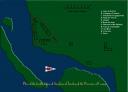
1795: The Malaspina Expedition arrives in the Philippines to gather scientific data on the islands.

1811: Map of Manila published.

1815: End of the Galleon trade.

1845: Earthquake damages the city


Establishment of World Trade (1848-96)

1848: Opening of Manila to world trade.  No longer dependent on the Manila galleon, the government opens Manila to direct trade with foreign countries. This spurs the development of Binondo and neighboring districts as the new commercial center of the Philippines.

1851: Map of Manila in Buzeta y Bravo

1859: Jesuit return to the Philippines, given charge of the Ateneo Municipal de Manila.

1861: Jesuits are sent from Manila to open mission in Mindanao and take over parishes vacated by the Recollects.

1863: Earthquake damages San Agustin, the cathedral, the Palacio and the Ayuntamiento.

1872: Earthquake damages the cathedral further.

The Filipino priests, José Burgos, Mariano Gomez, and Jacinto Zamora are executed at Bagumbayan. They are implicated in the aborted revolt at the Cavite shipyard.

1877: First volume of the grand edition of Flora de Filipinas appear. Subsequent volumes appear in 1878 and 1879. This work of Manuel Blanco, O.S.A. who set up a garden of tropical and medicinal plants in the second cloister of San Agustin was illustrated by noted artists of the era, Spanish and Filipino.

1889:

27-31 July: Jesuit inaugurate San Ignacio church, designed by Felix Roxas. Construction began in 1878.

1894: Augustinians acquire properties near the second cloister on 40 Calle Real and 7 Santa Lucia for a proposed Procuración General-Hospedaría-Enfermaría. Building was completed in 1898.

1895: Benedictines arrive in the Philippines.

1897: Capuchino church completed.


Philippine Revolution and Independence: 1896-98

1896:

17 – 30 August: The revolutionary Katipunan is discovered. Revolution against Spain breaks out, led by Andres Bonifacio.

30 December: Execution of José Rizal, after being detained in Fort Santiago from 26 December

1898:

12 June: Gen. and Pres. Emilio Aguinaldo declares Philippine independence in Kawit, Cavite.


American Occupation: 1898-1946

1898:

10 December: By virtue of the Treaty of Paris forged by Spain and the United States, the Philippines, which included Guam and the Marianas, was ceded to the United States.

1905: Convening of the first National Assembly in the Marble Hall of the Ayuntamiento.

December: Noted city planner, Daniel Burnham visits the Philippines to draw up master plan for the cities of Manila, Baguio and Cebu.

1906: Burham plan is put into action. Intramuros’ moat is drained and filled with sand and soil. Low forward structures are buried in the sand, for instance, the bridge that connected the Ravelin de la Puerta Real with the street outside the city walls. The backfilled moat is developed as a nine-hole golf course. Originally known as Muni(cipal) it is now called Intramuros Golf Course.

1932: Fire ravages the southwestern quadrant of the walled city. The Ateneo de Manila building is burnt, forcing the transfer of the school to Ermita at the site of the Colegio Normal de San Francisco Xavier.


Second World War: 1941-1945

1941: Second World War reaches the Philippines when Japanese planes bomb Manila in the morning of 8 December, after a successful attack at Pearl Harbor.

December: Manila declared an Open City.

1945:

February: Massive destruction of Intramuros during the mortar and artillery bombardment by American troops in February. Massacre of Filipino civilians in Intrarmuros, especially in Fort Santiago where civilians and POWs were detained by the Japanese.


Peace and Restoration: 1946 to present

1946:

4 July: America recognizes Philippine Independence.

Intramuros lapses to oblivion, the damaged buildings and walls become havens for the homeless and dispossessed.

1966: Restoration of Intramuros begins with the help of the Armed Forces Ladies’ Committee.

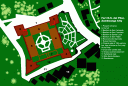
1979: Creation of the Intramurros Administration under the Ministry of Human Settlements.  IA created by PD 1616. Declaration of Barrio San Luis as a special historical zone; it center was the house museum, Casa Manila.


2002: Administration of Intramuros as a special historic zone is transferred to the Department of Tourism. DOT launches WOW Philippines program and includes the transformation of Intramuros as a popular tourist destination. DOT refurbishes the walls and streets; builds a replica of the Beaterio de la Virgen (forerunner of the RVM sisters, founded by Mother Ignacia del Santo Espirtu). The new structure houses a museum of Philippine history, extolling the ethos of volunteerism.


26
Jan
08

Fort La Playa Honda • Botolan, Zambales

03-playa-honda-copy.gif

This is one of the early fortifications built by the Spaniards in the bid to consolidate rule in Luzon. As early as 1617, the Spaniards under Juan Ronquillo damaged three of the six Dutch ships led by Admiral John Derickson Lamb. The battle that lasted two days off the Zambales coast is one of the many naval battles waged between the Dutch and the Spaniards for control of trade in insular southeast Asia. The conflict begins in 1606 when Spaniards under Gov. Gen. Acuña drives out the Dutch from Tidore, which the Dutch had earlier seized from the Portuguese. Spain gains control of the Moluccas. The vulnerability of the western coast of Luzon facing the south China Sea and near the entrance to Manila Bay plus the Zambals who attacked the colonial settlements convinced the Spaniards to build a fort at Playa Honda (Botolan). Playa Honda was the name originally given to Zambales, its capital Paynauen meaning resting place is now Iba, consequently the fort was also known as Fort Paynauen. The Zambals, called fierce by Spanish documents, were subdued by the presence of a well-garrisoned and equipt fort. Until is constitution as a separate province in the late 18th century, Zambales fell under the jurisdiction of Pangasinan.

 The clearest documentation comes from the Valdes Tamon 1738 report.  Details of construction are uncertain. The ruins were documented by National Museum before the fort was further damaged by lahar after the eruption of Mount Pinatubo in 1991.  Located near the shore at the mouth of the Bancal River, the fort was between the towns of Iba (former name Paynauen) and Subic. The site as built plan is in the National Museum, Restoration Department.

26
Jan
08

Fort San Pedro • Iloilo City

06-iloilo-copy.jpg

The fort traces its history to the expedition of Esteban Rodriguez de Figueroa in 1595.  For the projected conquest of Mindanao and ultimately Brunei, a garrison and way station was established in Iloilo, the capital of Ogtong province, the name given to the southern part of Panay Island. A stone fort, dedicated initially to the N.S. del Rosario, was begun in 1616 as defense against the Dutch who were attempting to expand their hold on insular Southeast Asia. (Other sources indicate that the fort was completed in 1616 and begun in 1603.)

The fort was approximately 60 x 60 meters; its wall was 4 meters tall and 10 meters thick The Valdes Tamon report records a quadrilateral fortification with four corner bastions, three with orillons, and the fourth plain. G.J. Younghusband writing in 1899 describes the fort as “square, measuring about 80 yards each way.”

In 1617, the Dutch attacked Iloilo and in the foray burnt the fort but were repulsed by reinforcements that arrived from Manila. The fort was apparently renovated before 1738, by then it was known as San Pedro. The fort was slightly renovated in 1820 under the direction of the Maestro del Ramo de Fortificaciones, Joaquin Pabalán.

By the 19th century, Iloilo rose in prominence as an international port, which was used for the transport of raw sugar produced in the large-scale agricultural complexes in Panay and Negros. The British consul Nicolas Looney, who introduced steam-driven sugarcane presses, is credited with modernizing the extraction of sugar with the consequence greater sugar production, and hence the viability of trading sugar abroad.

While Fort San Pedro remained standing, its importance as a way station and rest area for ships and soldiers destined south waned.  Spain had opened other ports elsewhere, for instance at Sual and San Esteban in Luzon, Cebu and Zamboanga in the south and shipping by the 19th century had greatly improved when steam driven metal ships were brought from Europe.

The fort was built at the mouth of the Panay River and very close to the sea, which threatened its stability. In fact, in the 1738 plan in Valdes Tamon, two bastions and a curtain facing southwest are built over the bay waters.

In February 1899, the United States took control of the fort and from 1900 to 1941 used it as a garrison for the Philippine Constabulary and the Armed forces. But as Younghusband describes the fort was in dilapidated condition such that  that “its sea walls are so undermined by the action of the waves that one well-placed modern shell would tumble the whole structure into the sea.” Furthermore he adds: “Beyond the useful but hardly aggressive sandbag there are no engines of warfare in the fort, no guns in position of even the smallest calibre or most ancient pattern.” In short, the fort was useless. In 1910, an intense earthquake damaged many structures in Iloilo Province. Damage was recorded in the city and as far west as Oton. It is presumed that the fort was damaged during the earthquake.

During World War II, the Japanese used the fort a prison for war prisoners and captured USAFE forces.  Much of the fortification was still standing before World War II, although dilapidated and despite threats to its stability, but in March 1945, the fort and much of the city was bombarded by American soldiers.

Damaged during the war, the ruins were demolished and the ground leveled for a park, presently called San Pedro Park.  Foundations of the southwestern wall, consisting of large coral blocks, remain and are incorporated into the breakwater. The outline of two southern bastions and a stretch of curtain wall are still visible in the configuration of the breakwater.

26
Jan
08

Fort San José • Tandag, Caraga

13-tandag-copy.jpg

In 1605 a punitive expedition under Gen Juan Manuel de la Vega was sent to Tandag, but at the sight of the fleet the bellicose inhabitants, called Caragas, withdrew to the mountains. However, the inhabitants continued resisting Spanish attempts to establish a colony on Mindanao’s Pacific or eastern coast and were raiding the nearby Visayan islands for slaves. To put an end to the Caraga slave raider, in 1609, Gov Gen Juan de Silva sent a fleet with more than 400 Spanish and native soldiers. He also had a fortification built. His strategy was to contain the natives before they could organize as slaving parties.

Thus, Fort San José in Tandag was built to contain the local tribes rather than to repel raiders who came through sea. The fort was soon put to the test when 3000 Caragas attacked the fortification—unsuccessfully.

Later, however, as the inhabitants of Tandag had converted to Christianity, the fort functioned like other forts in the archipelago as coastal defense. And this was their principal purpose during the height of the Moro raids.

In 1622, the bishop of Cebu, Pedro de Arce, entrusted the care of Tandag to the Recollects. From Tandag the friars, initially eight of them, set out to convert the surrounding villages, from Gigaquit to Siargao Island. In 1754, Maguindanaos attacked Tandag.  Despite great odds the defenders held on as long as they could. But the fort was breached and damaged during battle. But as result of the raid, the town was eventually abandoned. It is not clear what happens to the fort at this point. Was it abandoned? Or did a garrison remain to keep and man the fort?

In 1761 and 1767, the fort was attacked again suggesting that the fort was apparently rebuilt after the 1754 battle. During the 1767 attack, Fray Valerio de San Agustin who had left Tandag to establish the town of Cantilan returned with force of 200 native militia and seven armed sailboats. His timely intervention saved Tandag but at the cost of heavy casualties.

The fort was in a bad state in 1796, when it was recommended that it was better to abandon the fort and transfer the troops, half to Baganga (now Davao Oriental) and half to Caraga. A report of 1797 stated that the fort was in ruins because of an earthquake, the storeroom was completely useless and the prison wall was nothing more than wooden stakes and that another earthquake would completely demolish the fort. However, Schreurs remarks “The fort was obviously not demolished” despite the fort’s destruction in 1613 and the 1754 siege by the Maguindanaos and the damaged caused by the 1796 earthquake, Schreurs argues that the ruined fort stood until 19th century, because a document in the series “Erreccion de Pueblos, Carga desde 1820 hasta 1823” (RMAO), mentions that in 1821 “one day 18 Moro pancos sailed passed the baluarte de San José de Tandag.” Then, the fort had garrison had a contingent of one corporal and three soldiers.

The fort was triangular with two unequal bastions at the corners and third demi-bastion as noted in the 1738 Valdes Tamon report.

Only the foundations of the fort remain today but is barely significant.

26
Jan
08

Fort Nuestra Señora del Pilar • Zamboanga City

 Fort Nuestra Señora del Pilar Zamboanga

The fort traces its origins to the efforts of the Jesuits who petitioned Gov. Gen. Juan Cerezo de Salamanca to establish a fortification at Zamboanga because of the threat from the Muslim communities in the area, which made evangelization difficult.  The governor established a special tribute called “la ganta de Zamboanga,” because a ganta of rice was collected to finance the construction of the fortification.

The first stone fortification of Zamboanga is the work of the Jesuit Melchor de Vera. De Vera, who had knowledge of military architecture, was earlier assigned to the Jesuit mission of Carigara in Leyte. In Leyte, after a devastating raid and the revolt of Bangkaw, he broached the idea to his confreres to fortify the island. Around 1630, he began fortifying the missions on the island.

Toward the end of March 1633, the central government send a contingent to Zamboanga. We might surmise that this force built field fortifications to secure itself and establish a safe perimeter. Two years later (16 April 1635), a military contingent consisting of 1000 Visayans and 300 Spaniards arrived in Zamboanga  to augment the forces sent earlier. Under the command of Juan de Chaves, the expedition left Cebu for Zamboanga with the express orders to establish a fort. De Vera arrived with the expedition in Zamboanga, as de facto military engineer. De Vera brought his experience in the Leyte missions to Zamboanga when he planned a fort. Its first stone was laid on 23 June 1635. Once completed, the quadrilateral bastioned fort was named in honor of San José.

From the very start, construction was met with serious objections by those who questioned its utility and the cost of sustaining a military contingent in a place far away from Manila.  Gov. Hurtado de Corcuera who succeeded Cerezo ordered a full report on the fort. The council reported that they could not find the proper documents authorizing the construction either from the time of Cerezo or of Távora his predecessor.  The question turned academic when Corcuera occupied the Zamboanga fort and paid for the fort’s water system from his own funds.

This earlier fort’s history was fleeting because Gov. Manrique de Lara consolidated the Spanish military might in Manila in preparation for the immanent invasion of the Chinese leader Koxinga, who had forced the Dutch out of Formosa (Taiwan) in 1661. With the troops withdrawn in 1663, the fort was abandoned.  Ironically, Koxinga did not accomplish his plan, as he died.

The governor’s action was severely questioned because had not obtained royal permission to do so.  Manrique had perforce to write a report defending his actions. In 1666, the Jesuit provincial Luis Pimentel asked the government to rebuild the fort as a security for the missionaries in Zamboanga and to secure Spanish position in the south. The following year a royal order arrived to study the situation and a council of war put together presented its opinion in 1669 that reestablishing such a fort was important.  On 26 August 1672, a royal decree ordered the establishment of a fort and permanent garrison, however it was not immediately carried out for lack of manpower and resource and because the Spaniards did not want to antagonize the Muslim leaders of Mindanao with whom they had a good relationship.  Another royal order arrived stating that the fort’s reconstruction be done with great caution to avoid undue antagonism.

Although Fort San José was still standing, the native inhabitants tried to demolish it, but succeeded only in destroying the quarters but not its stout walls.

Juan Vargas de Hurtado suggested building an altogether new fortification at La Caldera as the site was more salubrious and had abundant water. He was able to collect 30 thousand the first year, and 10 more for three subsequent years towards the expense of construction. Vargas’ successor, Gabriel de Curuzalegui, ordered a full report on the status of Zamboanga. In reply, a document was drawn up in 1685 stating that quadrilateral fort with the structures outside and protected by a perimeter wall was still standing. But what to do with Zamboanga remained an open debate until the end of the century.

Effective steps to reopen Zamboanga began with an exploratory expedition sent by Gov. Gen. Fernando Manuel de Bustillo in 1718.  Sergeant major Gregorio de Padilla y Escalante volunteered to head the expedition with Juan de Ciscara designated as peritus engineer.  The questions to be answered were whether it was better to transfer the fortification to La Caldera or not and to assess the work to be done.  Instructions were given that the fort was to be renamed Nuestra Señora del Pilar de Zaragoza and its bastions named in honor of three monarchs, San Felipe, San Luis, and San Fernando, and the fourth in honor of San Francisco Xavier, who was believed to have preached in Mindanao.

Ciscara’s opinion was that the Caldera site was too small, and that although the walls of Zamboanga had been reduced to half its height, it would take about a year to get it and its water system in shape and remodelled to better and more adequate specifications.

The expedition left Cavite on 14 November 1718 and arrived in La Caldera on 1 April the following year. While gathering information on the sites, the expedition they built a temporary fort at La Caldera. By the 5th they were in Zamboanga and on the 8th took solemn possession of Zamboanga and immediately went to work cleaning the area, and fortifying it with a temporary palisade of wood, fascines and parapets of cestones (basket-like containers filled with soil) built over the remaining walls.

The year when Fort Pilar was completed is stated as1719. The restored and upgraded fortification designed by Ciscara was put to a severe test when on 8 December 1720, 100 vessels, bearing thousands of warriors under Datu Dalasi (Dalusi) attacked Fort Pilar. During the siege, Dalasi was struck dead by a large rock hurled at him by the defenders. He fell into the moat and the attackers quickly retreated. But soon the siege was resumed, leadership fell on the shoulders of Dalasi’s brother, aided by the Sultans of Jolo and Maguindanao. Meanwhile, a priest emissary was able to leave the fort, arrive at Manila to request aid for the Zamboanga fort. Although an expedition was authorized, the fleet arrived at Cebu and there laid anchor, refusing to go any further.

The besieged defenders of Fort Pilar had to bear the brunt of attacks for two more months, when the attackers withdrew unable to take the fort and its stout walls.

Meanwhile, doubts about Zamboanga’s viability as a military position was debated in Manila, La Caldera was being promoted by some quarters as a viable alternative.  The Jesuits when consulted, however, said that although they favored establishing a community of relocated Boholanos in La Caldera, Zamboanga was to be maintained as the two together formed a formidable barrier.  Fernando Valdes Tamon in a report of 1731 gave his opinion that a settlement in La Caldera should not be allowed.  Meanwhile, around the Fort Pilar a small settlement had grown. Around 1734 it was a sizable community to which the 100 Boholano families to be relocated to La Caldera were allowed to establish themselves at the cost of the government with the added incentive of acquiring lands and temporary exemption from tribute and corvee labor.

In the 1738 report of Valdes Tamon, we see depicted Fort Pilar with the adjacent town surrounded by a protective wall with bastions (DT 1959: 362-75).

Planned as a quadrilateral Fort Pilar had plain bastions at three corners and one with orillons, facing the sea.  The main gate of the fort was remodeled in 1734 and relief of the Virgin del Pilar put above it.

In the 1734 map of Murillo Velarde a town surrounding the fort is depicted. This town is surrounded by a wall. Delgado describes this settlement as “ciudadela cerrada con dos baluartes.” Apparently the citadel was improved to surround the whole area by the turn of the 18th century it was enclosed by a wall laid following an irregular pentagon plan and had five bastions.

The fort was further improved in the late 19th century.  Plans for new kitchens at Fort Pilar are in the records of the Philippine National Archives.  In the 20th century, the Americans took charge of Zamboanga.  While maintaining Fort Pilar, they demolished the remaining walls surrounding the settlement to make way for Petite Barracks.  Only the memory of this citadel remains in the name Santa Barbara, given to the district around fort.  Santa Barbara was the name of the principal bastion of this enclosed town.

The Americans improved the water system of the fort, building an aqueduct that brought water to the new poblacion of Zamboanga, which was being built around Plaza Pershing and a city hall completed in 1905.  The aqueduct’s path, which passed through Petite Barracks, was landscaped with stately palm trees and was a favorite recreation site of Zamboanga.

The Second World War destroyed Petite Barracks, which was never rebuilt. In its place a market, the Barter Trade Zone, was established in the 1970s and the site of Spanish Zamboanga remains today an open field. Fort Pilar was also damaged by war. The National Museum of the Philippines undertook restoration and reconstruction of the fort. Work began in 1980 with the reconstruction of three damaged structures inside the fort. A fourth structure was left as it was. Restored as it looked in the 19th century, the fort is now a museum and an elegant venue for receptions, art exhibitions, and other cultural events. The museum galleries, housed in what were military barracks and offices, has on permanent display the 18th century finds from the Griffin, a ship that sank off Mindanao, and ethnographic and marine biology exhibit. A gallery near the entrance is for changing exhibits. The exterior is a shrine to the Nuestra Señora del Pilar.

26
Jan
08

Fort San Pedro • Cebu City

spedro_gatejpg.jpgThe fort traces its beginning to Miguel Lopez de Legazpi who laid out a plan for a triangular palisade at tongue of land along the shore of Sugbu (Cebu) in May 1565. After staking out the fort and a settlement outside its perimeter, the Spanish soldiers immediately built the fortification by felling trees and setting up a perimeter. Around ca. 1600, construction in stone began and may have continued until 1635. An engraving of unknown provenance (published in 1900 in Archipelago Filipino) attributes the stone fort to Gianantonio Campioni, an Italian Jesuit who designed the San Ignacio in Intramuros and who was one time rector of the Colegio de San Ildefonso in Cebu. The Colegio was located just north of the fort and was already a functioning school when Campioni was assigned to Cebu.

The fort, described in some documents as “cota,” appears in a 1730 map of Cebu. Records of this era indicate that the fort had a puerta empalizada, that is, an auxiliary palisade that protected the gate.  The palisade may have been a type of fausse braye.

In 1738, the fort was renovated.  The military engineer of the fort may have been Tomás de Castro who worked on various projects around this time. The fort is recorded in the 1738 Valdes Tamon report where the triangular design in clearly visible in a general map of Cebu.

The 1738 report describes the fort as “triangular in shape, with three straight-sided bastions, and measures 1,248 feet in perimeter. Its curtain walls are unequal in length and the gateway is on the curtain facing northwest towards the town. It is protected by an outer, square stockade, with gateway facing the town, and alongside this curtain is a stockade which acts as an outer rampart” (VT f83).

During the second half of the 1800, further renovations were done on the fort. This probably involved redoing the gate and the structure above it. A memorial stone with the date 1833 probably refers to the renovations done at this time.  Presently, where the fause braye should be is a low wall, now reduced and serves as convenient benches before the gate.  These may have been a replacement for the palisade-type fausse braye of 1730.

After 1945, although the structure was left undamaged during the second World War it had gone to seed. For a while it had the fort served as a zoo. Restored, it is today a park and its barracks house the Department of Tourism Office of Cebu and a branch of the National Museum of the Philippines.


January 2008
S M T W T F S
 12345
6789101112
13141516171819
20212223242526
2728293031