Archive for January 31st, 2008

31
Jan
08

Tanuan Fortification • Tanuan, Leyte

Tanuan may have been the first fortified church complex in Leyte. In 1630, Fr. Melchor de Vera, builder of the fort at Zamboanga City, first broached the idea of fortifying the Visayan churches against marauders. De Vera set the example, which others followed.

In 1610, Tanauan on the eastern coast of Leyte was founded by the Jesuits. In 1687, according to Putong, the Jesuits suggested that a church be built in the place. A Chinese migrant from Luzon, Juanillo Siengco who had arrived in Tanauan in 1661, was employed to build a church of wood and stone.

In 1704, the present Tanauan church was completed. This is the same year noted as the foundation of the parish. In 1768, Tanauan was ceded to the Augustinians then in 1843, it was transferred to the Franciscans. But the Franciscans were not able to provide personnel until 1846, when Salustiano Bus, OFM, began to minister in Tanauan—although intermittently. It was the following year, 1847, when the Franciscans were able to assign Francisco de Paula Marquez, OFM to take permanent charge of the place.

Fray Agustin Maria de Castro, an Augustinian assigned to Leyte after the Jesuit expulsion, lists Tanauan as among the towns with stone churches built by the Jesuits. He also notes the fortification made of stone and the supplies of armament in the church complex.

When the Franciscans took charge of the place they found a solidly built church with a defensive wall surrounding it and a bulwark at every corner. Huerta (1865: 349) describes the fortification: “[the church and convento] are found surrounded by a wall of stone of uniform dimension, with a bastion at each corner, the walls were built as a defense against the Moros, although the wall is greatly deteriorated.”

Fray Marquez, who was an avid builder, lengthened the church nave, so that the church measured 228 ft. in length and 22 ft. in width. To disguise the ungainly proportions of the church he added a chapel at the gospel side, 42 by 42 ft. in dimension.  In 1850, he repaired the convento and its roof. In 1860, The church may have been further repaired by the addition of a transept. A memorial marker is found on the transept wall with this date. 

The church fabric as repaired by Marquez has been greatly altered by 20th-century renovations. The convento is now a school. Some fortification walls still stand behind the church. But the church has a new façade and bell tower. The interior has been repainted and the old retablos replaced by new ones. The Stations of the Cross and the image of Our Lady of the Assumption, the patroness, may be old; the statue probably dates to the 18th century.

Tanauan traces its fortification to the Jesuit Melchor de Vera who in the 17th cent broached the idea of fortifying the mission churches of the Visayas. It is uncertain what type of fortification de Vera built. Was it mortar and stone or a field-type, consisting of a palisade fortified with earth? The present fortification was in construction until 1704. It is now impossible to determine which part of the fortification is the handiwork of de Vera and which part is of a later construction. In 1884, Huerta asserts that the walls were already in disrepair. Today, very little remains of the fortification. Some walls stand behind the church apse.

31
Jan
08

Hilongos Fortification • Hilongos, Leyte

The greatly renovated church of the Immaculate Conception is an integral part of the fortification at Hilongos.  The old entrance, formerly the main entrance to the fort, is now blocked and the old nave converted to the transept of a new church.  Part of the fortifications walls and some bastions remain.  A ruin stands beside the church, probably the older convento. A newer convento has been built inside the fortification.

Lore has it that in the 12th century Amahiwan, an Ilongo from Iloilo, conquered neighboring barangays on Leyte’s western shore and extended his territory to the present limits of Inopacan, Hindang, Bato, and Matalom. He formed a settlement and named it Hilongos, because its inhabitants were Ilongos.

In 1710, the Jesuits established a residence there. In 1737, according to Redondo (1886, 207), Hilongos was already a parish before this year. However, Braganza (table 5) claims that Hilongos became a parish only in 1737. This year corresponded to the establishment of the town (Tantuico, 41). Redondo reports that as of 1884 the year 1754 was the date of the oldest parish books (deaths).

In 1768, the Jesuits ceded Hilongos to the Augustinians. From 1774 to 1779, the Augustinians established schools in Hilongos.  In 1784, Palompon, a Hilongos visita, became an independent parish. This data seems rather strange because Hilongos was already a principal house of the Jesuits. Most likely, after their expulsion, the status of Hilongos was downgraded and the town placed under Palompon.

Fray Agustin Maria de Castro, an Augustinian assigned to Leyte after the Jesuit expulsion, lists Hilongos as among the towns with stone churches built by the Jesuits. He remarks about the stone walls surrounding the church and its artillery pieces. Of these walls large portions and a watchtower are still intact.

In 1862, Manicar led a revolt at Barrio Sta. Margarita.

In 1873, Leovio Magia led a revolt. Unlike the towns of eastern Leyte, which were ceded to the Franciscans in 1843, the towns along Leyte’s western coast fell one by one under the seculars.

Church complex—Redondo attributes the present church’s bell tower to a secular priest Don Leonardo Celis-Díaz, a native of Cebu. The building of the church fabric itself is disputed. Did Celis-Díaz build it or did he merely repair an older structure left by the Jesuits? Oral lore claims that the church and the ruined convento behind it are from the Jesuits; but Repetti reports otherwise. Certainly, there must have been some permanent structures when Hilongos became a residence. Examination of extant remains indicate that the church and the surrounding walls were built as one ensemble and is akin to 18th century construction.

It is quite clear that the church complex underwent major renovations over the centuries.  The original church, now incorporated as a transept, was a single-nave structure whose main door was also the gate to a bastioned fortification. Some bastions and walls of that fortification still remain.  The main nave of the church is a modern construction, and the bell tower build by Fr. Celis-Diaz is an independent multi story structure, now plastered over with Portland cement.

The church interior is completely new in contrast to the convento which may have been completed in the 19th century.  The convento guards many of the church’s antiques including silver vessels from the 18th century.

A fortification surrounds the church to which an older church façade is attached suggesting that the fort was coeval to this old structure. There is very little data on construction otherwise.

31
Jan
08

Catbalogan Fortification • Catbalogan, Samar

The Jesuits first landfall in Samar was a place called Tinago in the Municipality of Tarangnan in the year 1595. That same year, Francisco Otazo, SJ founded the Catbalogan mission. It became the principal mission on Samar’s western coast, when Tinagon was struck by famine and disease causing the Jesuits to abandon the area. This increased the importance of Catbalogan but it was vulnerable and subject to frequent seaborne attacks. During one such attack, the village was burnt and its Jesuit pastor killed. Three known martyrs of Samar were Gabriel Coronel who died 27 May 1627; Ignacio Zapata, died 8 Jan. 1666; and Francisco Angel, died 24 Feb. 1674 on Maripipi island (Redondo y Sendino, 94; HC [608] gives the year of Angel’s death as 1676).


In 1627, Catbalogan was raised to the status of residencia (residence or central house) and among its dependencies was Paranas (Wright) where in 1629 Fr. Pedro Estrada is reported as actively evangelizing the area.


The Annual Letters of 1631–32 report that because a fort was constructed in Catbalogan and the townspeople could now live in peace near the fort.  Annual Letters were periodic reports which Jesuits superiors sent to Europe, to acquaint administrators in Rome and Spain of the status of the missions. Although they were meant to be dispatched every year to Europe, difficulties of sea travel made it such the letters were sent on the average every three years.


Aside from the fort, a stone house was constructed after three years of labor. In this house the altar of Our Lady was kept to protect it from typhoons. Obviously the church at this time was of light material as it could not protect so precious and expensive a thing as an altar.

According to Huerta the present stone church of Catbalogan was built prior to 1760. The date is based on the report that in 1760 or eight years before the expulsion of the Jesuits, this church was burnt. On 17 October 1768, Catbalogan was ceded to the Franciscans who received it from the Jesuits. The first Franciscan parish priest was Fray José Fayo. When the Franciscans arrived they found the Jesuits ministering to the spiritual needs of the people in a camarin (shack) of nipa, while the shell of the church, apparently saved from the conflagration, needed repair. Thus, since the fire the Jesuits did not have the resources to repair the church.

In 1769, José de Jesús Marín, OFM established an infirmary, but probably this building was also of nipa and bamboo.

The church did not assume its present from until in 1814, when Félix Carreón, OFM set out to repair the church. Martín de Yepes, OFM  constructed the altars of Catbalogan. He also had a colonnade of wooden posts raised, thus dividing the nave into three. The façade used Ionic columns for its articulation.

In 1835, The church burnt a second time but was rebuilt by the Franciscans. (Redondo suggests that there was another fire between 1814 and 1835 [Redondo 1886, 216].)

Church—Records are unclear about the extent of damage on the church. Huerta implies that the stone fabric withstood the fire of 1760 that consumed all that was combustible. But the fire of 1835 must have left little of the Jesuit church. Add to that the devastation of World War II and we have little left from Jesuit times.  If anything remains from Jesuit times, it might be the meter-high image of the patronal saint, St. Bartholomew, presently kept in the rectory.

Fort—Certainly parts of the fort behind the church trace to Jesuit times, Delgado’s description corresponds closely with what is left of the fort. Delgado’s words: “Catbalogan possesses a large fort, capacious and quadrilateral, and at the corners facing the sea two bulwarks with mounted artillery. The church and residence of the Fathers of the Society are built in the fortification. Two blockhouses were built at the landward corners of the fort.  The fort is always well-provided with gunpowder, bullets and other weapons because of the present need.  We are constantly under attack from all sides by Moro ships” (1754, 239-40).

It is not certain if Delgado is describing the fort mention in the Annual Letters of 1631–32, if so then the fortification behind the Catbalogan church is much older than the church. It could also be a later construction completed when the Jesuits built a stone church in Catbalogan.

Described by Delgado as “fuerza grande” with “muralla y baluarte” remnants of the fort walls and a stone blockhouse are found behind the Catbalogan church.  The enclosed compound is now a provincial jail. Landor (1904: 444) indicates that by the early 20th century the fort was already a jail and that its walls were deliberately demolished. This means that the existing fortification at Catbalogan is part of a more extensive fortification that may have surrounded the church complex. Landor writes: “Catbalogan, also on the west coast of Samar, … was a biggish town, with a handsome church, a large fort (turned into the provincial jail), the wall of which had in great part been demolished. The town extended mostly to the east of the fort… To the west a bridge connected the town with a small hill on which were the remains of an old Spanish block-house—a position occupied later by the insurgents, who placed a piece of ordnance here.”

The Franciscans were responsible for other architectural initiatives. They built the cemetery and its chapel dedicated to the Blessed Virgin, possibly the casa real of stone and wood near the church. The lower story of the casa is now the Philippine Constabulary barracks. Dates of construction are uncertain.

31
Jan
08

Capul Fortification • Capul Island, Samar

capul-stairs.jpgcapul-inner-fort.jpg

Capul belongs to a cluster of islands (Dalupiri [San Antonio], Destacado [San Vicente], Naranjo) on the San Bernardino Strait that guarded the embocadero, the gateway toward the Pacific Ocean, through which the Acapulco galleon sailed. Capul location was strategic. It was the last island where ships could replenish its water supply before sailing to the Marianas and Guam, the next landfall. One etiological legend has it that Capul is a corruption of A-Capul-co. Long time ago, it is said the galleon would dock at the island to provision itself with sweet and fresh water that gushed from an underground stream in a sitio south of the población. A sailor whiled his time by carving the name “Acapulco” on a rock. In time, the letters a, c, o abraded—and left behind the letters “capul,” hence the town name.

But from old, the townspeople called their island “Abac.” They spoke a distinct language, not the Waray of Samar or the Cebuano of western Leyte, or the Bicol of the Bondoc peninsula, but a language whose closest relation is found in the islands south of Zamboanga. The people call their language “Abacnon.”  It is probable that the inhabitants of Capul descended from migrants from the south who used the island as base of operation for slaving raids, or as oral tradition in the island suggests a refuge from those fleeing an abusive sultan in Mindnaao.

The Jesuits may have reached the island in 1610. This is the earliest date when we have evidence that the Jesuits were working in Capul. In 1616, A church was built, probably a provisional one of wood and thatch.  Capul at one time was considered an important house so that had as its visita Calbayog on Samar’s western coast.  Although its population was never very large (884 souls says Huerta in 1844) Capul maintained its strategic importance so that when the Jesuits left Samar, the Franciscans were assigned to the island as soon as they had the personnel. In October of the same year Capul the Franciscans assigned Joaquín Martínez OFM as the first pastor.

The Jesuits built a fortified church in honor of San Ignacio de Loyola in this island. By 1768, when the Jesuits left, the fortress or parts of it had been standing. We infer this from the report that Fr. Esandi, the last Jesuit priest of Capul, was killed on its ramparts by slave raiders. He never read the order of expulsion because when word reached Capul, Esandi was already dead.

In 1781, Fray Mariano Valero, OFM, repaired the church and built a bell tower. A tribunal of stone and a school of primera enseñanza were built by the Franciscans. In 1898, The Franciscans opened a lateral gate along the fort’s walls, and embellished this with the Franciscan emblem.

On 18 November 1869, Capul was created a parish in conformity to the episcopal decree of 12 September 1864. There were subsequent repairs on the church, for the townspeople still remember an altar in the neo-Gothic style. In 1947, the neo-Gothic altar was apparently destroyed when a typhoon hit the church.

In c. 1987, The church suffered destruction when a strong typhoon ripped the roof, ceiling, and part of the convento. The church was subsequently repaired but is pretty much an empty shell, save for a very new altar and renovated sanctuary.

In 1988, The baptistery to the gospel side of the nave, the sacristy behind the sanctuary and the convento’s second floor above it, needed repairs. The old choir loft was removed during the repair of the single-naved church.

The church of Capul is dedicated to St. Ignatius Loyola and is surrounded by a square fort with bulwarks of dissimilar designs. Both Jesuit sources and Huerta claim that the stone church traces back to the Jesuits but its date of completion is unknown. So too is the date of the fortress.

The Capul façade is Spartan, its only articulation are engaged pilasters and a split pediment around the central door.  Since the church façade forms part of the defensive wall, artistic decorations may have been deemed unnecessary and so were omitted.  Much of the fortification, including the bastions remain.  On the northeast bastion an iron cannon is still mounted.  From this bastion has a clear view of Samar.  Near the church complex is a small chapel, probably a mortuary chapel. 

On a hill near the Capul fort is a triangular watchtower. The year of its construction and its builder is uncertain. It could be coeval with the fortified church and if it is the tower complements the fortified church. 


31
Jan
08

Palapag Fortification • Palapag, Samar

Fortification and church of San Ignacio in Palapag was the center of Jesuit activity in northern Samar. The early church may have been built before 1649 and repaired after 1650. Probably a reconstruction of the church was done in the 18th century. The Jesuits to whom work in Palapag is attributed are  Fr. Otazo; SJ, Ignacio Alzina, SJ.

Fortification surrounds the church complex and has with a complementary watchtower, called “Centinela de Palapag” (Palapag Sentinel) about a five minute drive from the center of town.

Palapag’s location inland indicates that the fortified church complex was built no so much as a defense from seaborne raiders but as a defense from other hostile groups who as the Jesuits reported were initially resistant to conversion and evangelization. The Father’s search for security was most likely confirmed when the Sumoroy revolt erupted in 1649.

This does not mean that Palapag was immune to slave raids. Historical records show that the town had suffered attacks.

Today the journey to Palapag is by road and pumpboat. From Catarman, a well-paved highway leads to Rauis from whence one hires a pumpboat for a short trip to the island of Lauang or for a longer trip to Palapag, upstream.  It takes a good 45 minutes to reach Palapag and it advisable to visit it during high tide to avoid having to walk through mud as boats find it hard to dock beside the riverbank at low tide.

Palapag was the site of a residentia or central headquarters of the Jesuit mission in northern Samar or Ibabao. In this inland town in northern Samar coast was the second residence founded by the Jesuits, where the religious superior lived and where the members of a community returned after visiting and ministering to different places.  The residentia was also the place for the periodic meetings and spiritual retreats of the priests.

In 1597, When the Jesuits began evangelizing the area, they encountered a bellicose people, not too ready and open for conversion.  They were unlike the people of the western coast.  In fact, these people who called their land Ibabao, that is, the land above, looked down on the other islanders as lacking in courage.

A number of outstanding missionaries worked and died in Palapag. On 1 Jan. 1617, Fr. Gabriel Sánchez (co-founder of the Bohol mission with Juan de Torres) died and on 12 Dec. 1626 Fr. Manuel Martínez died.

A church is attributed to the work of Fr. Otazo, SJ but details of it are sketchy. Certainly, before 1649, the Jesuits had built a church complex consisting of church, residence and fortification. That year (1649) Palapag was the scene of the Sumoroy revolt, one of the sporadic revolts that would erupt during colonial times. The revolt began when Agustin Sumoroy, the castellan of Palapag, killed Miguel Ponce SJ, rector of Palapag, because Ponce had denounced his practice of concubinage.  The subsequent attack and sack of the church complex signaled a revolt that spread throughout Samar, the neighboring island of Mindanao and the Bicol peninsula.

Historians interpret Sumoroy’s violent response to Fr. Ponce’s denunciation, as a trigger for a festering discontent in the Visayas, which was caused by Gov. Fajardo’s unpopular conscription of Visayan labor for the Cavite shipyard. By long standing tradition and practice, Visayans were exempt from building galleons at Cavite because the Visayans supplied the crew that manned the galleons and the vessels of the Spanish navy that patrolled the archipelago. This breach in practice coupled with the distance to Cavite from their hometowns and islands spurred many to join Sumoroy. The Visayans were disappointed at the Jesuits’ inability to have the governor’s decree rescinded and this triggered the violence on the priest.

After Palapag, the rebels, led by Sumoroy, attacked Bobon, Barugo, Catarman, and Catubig, leaving their churches burnt. Sumoroy and the rebels set up their bastion at La Mesa de Palapag, a 378 meter mountain identified today as Mt. Boboyaon, which straddles the boundaries of Palapag, Catubig and Mapanas. Several attempts to capture Sumoroy and his men were fruitless, until the following year 1650, when driven by troops from Zamboanga and surrounded in his mountain lair north of Palapag, Sumoroy, while escaping was killed by his own men who then sought clemency from their pursuers who had outnumbered them.

It seems that by 1650, Palapag had repaired parts of the church complex as it is reported that the convento of stone and wood also served as a fortress. Further on, Ignacio Alzina (1668) reports that he had begun rebuilding the church of Palapag in masonry. Alzina, famous author of Historia de las islas e indios Visayas, spent much time in Palapag where he was assigned as rector or mission superior. Alzina is also known to have compiled a multi-lingual dictionary of the Visayan languages. (We infer that most of Alcina’s history and literary work were written in Palapag.)

Alzina’s writing confirms other reports that the Palapag church was fortified and that this was destroyed during the 1649-50 revolt, but he adds that the fort was rebuilt immediately after the revolt. But, whether the present ruins around Palapag church trace to the 17th century is uncertain. 

Writing in 1754, Jose Delgado (Historia sacro-profana, 1754: 239-40) records as a matter of fact the existence of a “muralla y baluarte” in Palapag. However, he notes its degraded condition: “Palapag in Eastern Samar has an old wall with its bulwarks and blockhouse.  It has a few iron cannons.”

The precise year when the ruined Jesuit church at Palapag was completed is unknown. Certainly the Jesuits left a stone church, for Huerta wrote, “The church, under the advocacy of Our Lady’s Assumption, has a solid fabric, and was built by the Jesuits. They too built the parochial house.”  Redondo (1886) describes the church as having a thatch roof.

In 1769, slave raiders attacked Palapag during which many died.  The church may have been damaged by the attack.

In 1843, the Franciscans who took charge of the parish, after the Jesuit expulsion in 1768, repaired the church and convento; then in 1846 they refurbished the altar.

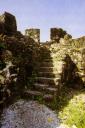
The old church was badly damaged by a typhoon and never rebuilt.  Part of the fortification and some bastions remain. (See FHL AR00263 for a photograph of the Palapag fort)


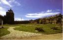
The core of the fortification is the solidly-built Jesuit church, now a ruin. It stands parallel to a new parish church built in the 1980s.  By then, the Jesuit church had lost its roof, ceiling, and other appurtenances in a typhoon. The damage was so extensive the parish decided it was not worth the cost of rebuilding, especially since the town’s fortune had waned substantially. The old convento was built perpendicular to the Jesuit church to form a typical L-plan. Greatly degraded, that convento was torn down and a new one built (See Repetti for a photograph of the church and adjoining convento).


The ruined Jesuit church is cruciform, its façade flat and articulated with engaged Doric pillars. It has a central door whose capstone bears the Society’s colophon. There is an inscription on the door jamb difficult to decipher. This may have been a memorial stone to commemorate the date of construction and reads, “Mes de [ ] 8, siendo Cap.n Dn Pedro de Alcan [ ] Ao.” It has entrances at the transept crossing. No bell tower, though probably there was one but now long gone.


Remnants of a fort exist especially to the rear of the church and to the left of the façade (facing it) where the foundation of a circular bastion or tower exists. The fortification’s perimeter can still be traced but with some difficulty. The interior of the fort perimeter is crowded with vegetation, the outer sides of the curtain wall and the existing bastions are covered by dwellings built beside it. The wall appears to have extended to the cemented plaza in front of the church. A portion of curtain wall and a quadrilateral bastion, although much degraded still stand. A complementary bastion and wall can be inferred from the traces left on the ground. 

31
Jan
08

Dauis Fortification • Dauis, Panglao Island, Bohol

Delgado reports a stone fort and baluarte in Dauis built during the Jesuit era. Oral tradition locates this on the grassy field adjacent to the epistle side of the church. The reported site of fort from Jesuit times is adjacent to the convento. Using Delgado as a time marker, we can surmise that the fortifications was built by the 18th century. Most likely it was the work of Joseph Nepomuceno, SJ.

The shallow Dauis Channel was the site of a pre-colonial village built on stilts.  Prior Spanish colonization, this village was attacked by a combined force of Portuguese and Ternateños who came disguised as traders.  The result was the dispersion of the survivors.  Some went to Baclayon to found a settlement there, while others took refuge in Dapitan in Northern Zamboanga. As this experience had shown, Dauis Channel was vulnerable to attack. So its defense was essential for the security of the settlements along the seacoast.

The history of Dauis fortification is intimately tied with the history of its church building.

Jose notes a discrepancy between the local historians’ list of parish priests in Dauis, which begins with the year 1679 and Javellana’s statement that the Jesuits assigned a permanent missionary to Dauis in 1697. Recollect historian Cavada says that the parish was founded in 1720. This lack of unanimity indicates that there is no clear indication when the parish was established, although Redondo’s 1886 survey says that the oldest canonical record known to him was a libro de bautismo that began on 20 January 1697, suggesting that the 1697 date might be the correct one.

In 1735, Jesuits moved the residencia at Lóboc to Dauis. What precipitated this move is uncertain, perhaps, Lóboc was considered inconvenient. Although not remote it took some doing to sail upstream and perhaps at this period, when construction in stone and mortar was done in earnest (what de la Costa calls the “golden age” of Jesuit church building) the Jesuits were confident that they could fortify Dauis, even though it was in a coastal area. In 1753, Joseph Nepomuceno, SJ is recorded as building a church, that replaced an earlier one of light material, which Jose surmises “may have been built before 1692” (Jose, 2001, Visita p. 43). The following year Jose Delgado SJ reports the presence of a stone fort and baluarte at Dauis.

The Recollects took charge of Bohol in 1768, and in 1769 is reported to have built another church. This suggests that the 1753 church was in ruins. It may have been built of light material as resources were concentrated on fortifying the complex. It is quite possible that it was damaged by fire, typhoon or earthquake, although regarding earthquakes Repetti does not report an earthquake hitting Bohol between 1750 and 1770 (1946: 166-168). While authoritative and based on primary sources, Repetti’s list is dependent on sources, known not to be complete. In 1795, this church burnt and a fourth was built, which is described in Redondo as made of tabique  and nipa. The church was located along the same axis as the present convento and formed a continuous line between church and convento, forming an I-plan rather than more usual L or U. Jose postulates that this fourth church is the one depicted in the 1920s ceiling painting over the convento’s sala.

This fourth church was still standing when Fray Julio Saldaña, OAR (parish priest 1861-98) began a new church in 1863. According to Redondo this fifth church measured one meter longer than the fourth church, nine meters  wider and six meters taller. By 1879, Saldaña commemorated the completion of the first level of the façade by inscribing the date 1879 and his name above the principal arcade. This part was in the neogothic style. In 1884, disaster hit the church when the four arches supporting the cupola collapsed.

Work on the church continued to the 20th century. Fr. Natalio del Mar completed the façade in the early 1920s and Bishop Juan Gorordo of Cebu consecrated the church in 23 August 1923. Work continued and a year later a cross over the pediment was installed. The section built during the Spanish era can be clearly distinguished from 20th century additions, the lower part is made of stone and lime mortar and the upper section of cement. Only one of the two belltowers was completed. 

Nothing remains of the Jesuit- built fortification, although Javellana has suggested that the low wall bordering the plaza near the apse may have been part of the fortification. The rough and large coral blocks used for the convento suggest that the convento or parts of it may have come from Jesuit times. 


31
Jan
08

Dimiao Fortification • Dimiao, Bohol

Built during the las quarter of the 18th century with further work 1817-21, the fortification at Dimiao is traced to the initiative of Recollects, specifically Enrique de Santo Tomas de Villanueva, OAR (parish priest of Dimíao 1797-1805, 1806-1812, and 1815-1817) who worked on the construction with a maestro de obra. Built as a fortified church complex it was the principal defense of the town of Dimíao. 

Dimíao east of Loay was a mission station during the Jesuit era but became a parish under the Recollects. Its location along the littoral exposed it to seaborne attacks, hence, needed to be defended.

The fortification at Dimíao went through many stages, the chronology of which is sketchy because some data is unknown. Jose notes that “there is no conclusive dates for the foundation of the town and parish.” Redondo in 1886 says the earliest baptismal records come from 1750. Moreover, Jesuits do not mention Dimíao, which at that their time was probably a mission station or visita of Loay, which in turn belonged to the old town of Loboc. Recollects took charge of Dimíao with the departure of the Jesuits and toward the end of the 19th century was already a thriving parish that in 1869 Lila (to the west) and in 1871 Valencia (to the east) were separated from Dimíao as independent parishes.

It is likely that the Jesuits may have built a church of light material in Dimíao. During the last quarter of the 18th century, the Recollects surround “the early church and convento with a defensive wall.” What Jose means by early is uncertain, is it a church from Jesuit times or a church built by the Recollects, which they fortified. Fray Enrique de Santo Tomas de Villanueva constructed the present church from 1800 to 1815. A maestro de obras was from Camiguin was brought to build the church. Whether this meant he was born in Camiguin or was working on a project at Camiguin, an island under the Recollects, is uncertain. But this unknown craftsman is credited with building the Dimíao church and probably the fortification that protected it. Fray Enrique built a cemetery with an ermita at the same time and had to demolish the 18th century fortification partially; however, Fray Joaquin enlarged the perimeter of the fortification by building a new wall with towers at each corner. The cemetery with its stone-vaulted ermita was abandoned in 1844, under Fray Manuel Carasuan, and transferred a kilometer away.

Jose suggests that the vaulted chamber and remnants of walls near the main entrance of the cemetery unearthed by the National Museum archaeologists may belong to the 18th-century fortification. Toward the latter 19th century, the walls were no longer functional as the threat of raiders had diminished. Much of Dimíao town was burnt in 1901 by Gen. Robert Hughes during the Philippine-American war.

Some walls, foundations and what might be part of a bastion  or tower still stand; Jose notes “the thickly forested area to the left of the cemetery hides remains of various stone structures said to be parts of towers and fortifications” (Jose 2001: 46-49).

31
Jan
08

Loboc Fort • Loboc, Bohol

Loboc was an important inland town because it served as the marketplace where inhabitants of the inland towns Bohol could trade with the coastal towns. Besides the water borne raiders, Loboc may have been fortified to respond to the threat of people who lived in the hinterland. During the early 17th century and the 18th two major revolts erupted in Bohol—the Babaylan or Tamblot revolt and the Dagohoy revolt. In both instances, the rebels sought safety by fleeing inland. So an inland town like Loboc had to be defended in case of sudden incursions. 

Warren reports that the fortification of Loboc consisted of a stone church; stone fort and stone baluarte. It is not clear who built the fortification but it was most likely the Jesuits who had already built a new church in Loboc completed in 1734 to replace one built earlier but had been burnt. The sites of the baluarte and fort are uncertain. However there are ruins behind the convento, which may have been remains of the fortification.

There is little data about the fortification that can give a specific year or date of its construction or that can positively identify the fortification. 

31
Jan
08

Loay Watchtower • Barangay Villalimpia, Loay, Bohol

To protect Loay, the town was divided into a lower town (Ubos, aka Canipaan because of nipa swamps in the area) and an upper town (Ibabaw). The church is built at the upper town and the Villalimpia tower is in the lower town. This suggests that the tower at the seaside worked in coordination with the structures at the upper town. The watchtower allowed the townspeople to seek the safety of the upper town in case of seaborne attacks.

Historical records indicate that stone fort and stone baluarte are reported in Loay. It is not certain where the fort was, it may have surrounded the church complex at Ibabaw. The baluarte, however, is probably the watchtower located near the mouth of the Loay River.  It is presently at the edge of a mangrove forest, and accessible by sea.  During high tide, the sea reaches the tower’s foundations and has exposed and eroded it. Jose observes: “Along the coast of Villalimpia, a barrio near the mouth of the Loboc River, is an abandoned watchtower of coral stone and brick tiles. It can be reached after negotiating several mangrove swamps, and in fact is better seen from the water.  Tidal action has exposed much its rubble foundation, allowing for a detailed study of colonial construction techniques. Apparently the only access to the tower is by a ladder; there is no clearly defined entrance. Much of the original roof has survived. One wonders how useful this tower was, because of its diminutive height” (Jose 1998, 2001).

There are no clear records when the baluarte at Villalimpia was built. But a history of Loay might give a sense when the structure was built. Juan Delgado (1754) reports that the village of La Santisima Trinidad was a new village under the Jesuits. Redondo (1886) says that Loay became an independent parish in 1799, when it was separated from Loboc. The church at Ibabaw was completed in 1822 as indicated by an inscription on the church’s inner façade. An outer façade following a popular plan in Bohol that added porticoes in front of existing façades has the year 1889. Inside the church is a pipe organ dated 1841.

The convento is built behind the church and follows the line of the nave before turning left to form an L-plan. The date 1838 appears over the doorway facing the church and over the entrance facing the grand stone stairway (built ca. 1836-37) that links Canipaan and Ibabaw.

The bell tower, which is a separate structure from the church was built by Carlos Ubeda, OAR (parish priest 1859-1865). A date inscribed over the entrance to the tower carries the date 1865 and the phrase “Ave Maria PMA [Purisima]”. Other structures found at Ibabaw and around the church plaza two school houses built by the Recollects during the last quarter of the 19th century. Jose suggests that a two-story structure, said to be old tribunal or municipal hall and ornamented with the monograph of Mary, is from the 18th century.

The dates of these constructions suggest that there was much building during the second and third decade and the last quarter of the 19th century. As the threat of seaborne raiders had decreased considerably after the Gov. Claveria’s attacks on Sama Balangingi in 1841 and the campaign against Jolo in the 1870s, the second and third decades of the 19th century seems to be the more probably context for the construction of the Villalimpia watchtower.

31
Jan
08

Panglao Tower • Panglao, Panglao Island, Bohol

Redondo’s 1886 reports states that Panglao parish was established in 1803. Whether Panglao as a mission station or a reduccion already existed before that date is uncertain because both town and island are named Panglao. Thus, when the name Panglao appears in a 1612 document it is uncertain if the town or the island is being referred to. If the island, the town referred might be Dauis.

Within the Panglao church complex are the ruins of an earlier church, which despite the Baroque touches to the façade is dated to the 19th century. Inscribed over the main entrance is the date 1858 or 1859. Jose writes “the rest of the nave consisted of wooden posts and tabique walls which have since disappeared. It seems that his earlier church extended all the way until where the convento now stands. One wing of the convento would have continued the axis of the church, as we see in Cortes and possibly in the earlier church at Dauis” (Jose 2001: 87). This means that the convento is older that the present church at Panglao. Part of the convento is now a parish school, San Agustin Academy.

The present cruciform church of Panglao began construction under Valentin Utande, OAR (parish priest 1894-1897). Wood needed for the structure had to be procured from Sevilla and Loboc, inland towns in Bohol and had to be floated downstream and across the sea to Panglao. The scarcity of suitable construction material may be the reason why the church was still being constructed up to the second decade of the 20th century, when the greater part of the nave was completed. Stone facing, however, was not completed and the apse and transept lack the coral stones that sheathed Bohol churches. The church was consecrated by Bishop Juan Gorordo of Cebu on 1 September 1924, while a native secular priest Quiterio Sarigumba was parish priest. A portico facade of poured concrete was added to the church façade and has the initials of Padre Sarigumba—P.Q.S. A cement walk leading to the main entrance also is also inscribed P.Q.S. with the date 1925.

The history of Panglao church clearly shows that the five-story tower is not related to any of the dated constructions in the church complex. It antedated the ruined church by seven or eight years. This suggests that the tower belonged to an earlier era. Perhaps there was an pre-1850 church of light material. This  five-storey bell tower is located at some distance from both church structures and its proximity to the shore, now far more distant because of mangrove and coconut growth, suggest that it also doubled it served as watchtower. This corroborated by local oral tradition. Jose writes:  “A stone watchtower stands guard over the edge of the sea, a short distance behind the church.  Reputedly Bohol’s tallest, the ponderous structure bears the year 1851 inside its lowest chamber.  Its hexagonal plan is rare in the Philippines” (Jose 1998). In Visita, Jose adds: “interestingly another hexagonal tower stands in Dauis, on the opposite side of this island (built 1774)” (Jose 2001: 88; also See 07-40).

The structure is in poor condition.  The wood members have all deteriorated and there is no access to the top floor because the wooden stairway that leads up has disappeared. The stone walls bulges outwards showing signs of structural stress and deterioration and the tile roof has caved in allowing rain and moisture to enter. This creates an environment conducive to the growth of algæ and vegetation.


January 2008
S M T W T F S
 12345
6789101112
13141516171819
20212223242526
2728293031