Archive for January 30th, 2008

30
Jan
08

Fuerza de San Juan Bautista de La Lutaya • Agutaya, Palawan

In 1622, Palawan (Paragua) and the neighboring northern islands collectively known as Calamianes were entrusted to the spiritual care of the Augustinian Recollects by the Bishop of Cebu, Pedro de Arce OAR. Friars Francisco de San Nicolas, Diego de Santa Ana, Juan de Santo Tomas and lay brother Francisco de la Madre de Dios were assigned to this mission area. By 1623, the friars had crossed to the Palawan mainland but failed to succeed in conversion because of the strong influence of Muslim communities. Quite a contrast to the easy acceptance of Catholicism by the people of Cuyo and neighboring Agutaya. These fledgling Christian outstations were subject to attack by slave raider: 1632 Cuyo; 1636 Cuyo and Calamines; and in 1646 the raiders planned a concerted and massive attack on this frontier. In 1638, while serving as parish priest of Cuyo, Juan de Severo, OAR conceived of the idea to fortify the churches of Cuyo, Agutaya and Culion. While the friars built churches and residences and were advancing in their work, continued slave-raiding and lack of resources forced them to abandon Palawan briefly, except for Cuyo and Agutaya. This retrenchment set back the growth of the missions. In 1659, they returned determined to stay and so begun the construction of more durable defensive fortifications at Cuyo, Agutaya, and Culion, and also at Linapacan, Taytay and Dumaran, Malampaya, Calatan and Paragua (Puerto Princesa). In 1692, the mission at Agutaya was raised to the status of parish under the advocacy of San Juan Bautista. This is the same name given to the fort at Agutaya.

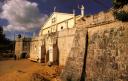
The fort built in 1683 was remodelled in the 18th century. It is not certain if the 17th-century fortification was a palisade or a stone fort. The plan for Agutaya appears in the Valdes Tamon report of 1738. Whether the fortification was built immediately is uncertain. A date given for the completion of the fort is 1784 and is attributed to the encomendero Antonio de Rojas who delineated the plan of the fort. Apparently, the earlier fort of Fray Juan was greatly modified.

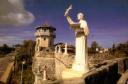
Landor (1904: 65) describes Agutaya “a fort with four battlements was the principal structure, and inside its quadrangle was to be found a simple and modest church, the windows of which were cut into the east wall of the fort. This house of God possessed a choir-balcony and the usual cheap images of the altar. On the northeast battlements, which was crumbling away were the remains of a high tower.”

The degradation of the Agutaya fort continues to this day. 

30
Jan
08

Cuarteles • Puerto Princesa City, Palawan

The details of construction are sketchy but it appears that the fortification was built in a short space of time; there is no evidence of additions during the Spanish colonial period. Built in the 19th century by the Spanish military it had military barracks, probably of wood, and a prison. It was built to defend Palawan’s capital Puerto Princesa, after the capital was transfered from Taytay.

Palawan was one of frontiers, which Spain sought to bring under Spanish rule. Also known as Paragua, the main island of Palawan was sparsely populated by indigenous tribes like the Tagbanua and the Tao’t Bato, in contrast to the northern island groups of Cuyo and Busuanga, which was populated by migrants from the neighboring islands of Luzon and the Visayas. Many were fisherfolk lured by the abundant fishing grounds of northern Palawan. 

An early 20th century postcard depicts a fortification built right in front of the Puerto Princesa church. The fortification consists of a pair of two-story quadrilateral towers projecting in front of a perimeter wall. At the towers’ lower registers are entrances leading into the perimeter’s interior. The perimeter wall, pierced by loopholes is not much taller than a standing person. The interior is almost completely occupied by a hip-roofed structure. The roof is made of metal sheets. The structure is morphologically closer to a blockhouse rather than a bastioned fort.

The postcard photograph suggests that this might be a fortified structure other than cuarteles because it is situated at the side rather than in front of the Puerto Princesa church. There is the possibility, though that the orientation of the church was changed over time. But then structural and design details, shown in the photograph, indicate an entirely different structure. The towers, for instance, are simple boxes supported by crisscross timbers. They have none of the articulation of the existing towers of cuarteles. There are no remnants of this second structure.

30
Jan
08

Fort Labog • Barangay Labog, Sofronio Española, Palawan

The historical marker for Fort Labo(g) reads: “Fort Labo. Site of Fort Labo built by the Recollect Augustinians to protect the town against pirates. The plans were prepared by Rev. Atilano de San Jose, A.R.. The fort, constructed with the permission of Governor Bobadilla, was demolished in 1720 by order of Governor Cuesta. Site: Labo, Palawan; Date installed: 1939; installed by Historical Research and Markers Committee” (NHI, p. 148).

It is not clear why the fort was demolished. Perhaps, the townsite was moved.

30
Jan
08

Dumaran Fort • Dumaran, Palawan

Warren lists a wooden baluarte or watchtower at Dumaran based on late 18th century reports by the diocese of Cebu on the defenses of the Visayas, which was under its ecclesiastical jurisdiction. If the fortification at Dumaran were made of stone and mortar conceivably the report would list it down as such. This might indicate that the ruined fort at Dumaran was built during the last decade of the 18th century or the early 19th.

The walls that remain at Dumaran consist of a bastion and short stretch of curtain wall, breached off center with an entrance. It is uncertain if the fortification was ever finished or that it had been ruined over time. Oral tradition claims that the fort was never finished and inspection of the evidence seem to corroborate the tradition.

The bastion is of an unusual shape consisting of a rounded projection at the center flanked by two short wall walls. The bastion does not conform to any typical shape. It is quite probable that the rounded projection is an older construction, possibly a circular tower of stone and mortar, which was then remodeled as a bastion.

30
Jan
08

Linapacan Fortification II • Barangay Caseladan, Linapacan, Palawan

Part of defense system built in Palawan by the Recollects from the 1620s to 1738, the mysterious ruins of a bastioned fort were recently discovered (November 2004) on Linapacan Island at Barangay Caseladan, said to be the original site of the town of San Miguel. Another set of ruins were found near San Miguel. It is uncertain if this or the fortification at San Miguel is the one referred to by the 1738/39 Report of Valdes Tamon as “muralla de piedra de figura irregular” or the one described in 1754 by Delgado a fortaleza. There are marked discrepancies between the Valdes Tamon description and the actual remains at Caseladan. The Valdes Tamon report shows a natural fortification strengthened by walls and other built structures. The Caseladan fortification may have been built after the Valdes Tamon report or may been a remodelling of the fortification reported in 1738.

The history of San Miguel, the principal settlement of Linapacan is unclear. Did it transfer sites more than once? If it did then Caseladan maybe one of many sites for San Miguel.

30
Jan
08

Linapacan Fortification • Barangay San Miguel, Linapacan, Palawan

This is one of two fortifications recently discovered by Cheyenne Morrison on the island of Linapacan. There are two structures, a lower and an higher fortification or bastion built unto the limestone hill beside the town of San Miguel, the principal town of Linapacan. The structure is overgrown by vegetation and straggler figs. Further study is needed to determine if this or the other fort at Caseladan is the one that is described in the 1738 Valdes Tamon report, where the fortification is drawn as a cluster of buildings surrounded by a perimeter wall that hugs the crest of a hill.

If this the structures at San Miguel are the ones cited by Valdes Tamon, then this gives an indication when the fortification was constructed, otherwise there is very little data on its history.

Landor (1904: 100-101) adds to our conundrum when he describes Linapacan because it does not correspond to any of the ruins discovered recently

“A mile or so farther we arrived at the town—about half a dozen huts among cocoa-nuts palms, scattered on the side of the hill, upon which an ancient Spanish stone fort overlooked the western bay.It was pentagonal in shape, with two angular bastions and three semicircular ones, with an inner area of 600 square feet containing a humble nipa church in a dilapidated condition, a shelter with three bronze bells, a rickety iron cannon on wheels—and some iron bullets for ammunition. There was all there was to the fort. The only noticeable portion of this of this structure was a vaulted door with a Spanish coat-of-arms elaborately and most artistically carved in stone, with graceful leaf ornamentations all around it. Seen from the outside, the wall of the fort looked much stronger than it really was, but where crumbling down from age—especially on its south and east sides—its flimsiness was apparent.” (Compare this description with the details on the other fortification discovered at Barangay Caseladan, Linapacan)

30
Jan
08

Cuyo Fort • Cuyo, Palawan

cuyo-rampart.jpgcuyo-falsabraga.jpg

Cuyo was strategically located between the islands of Panay and the Palawan main land. The island served as a stepping stone that linked Palawan with the Visayas and Luzon. Cuyo’s strategic position within a transportation and trade route made it imperative that it be fortified.

Built in 1683, the fortified church of San Agustin is attributed to Juan de Severo, OAR.  The NHI historical marker at Cuyo gives as construction date as “about 1680.” The next major renovation to the fortification was in 1827 when a belltower was built on top of one of the fort’s bastions.

Cuyo’s main municipal defense the complex housed both the church and convento. Cuyo fort provided a safe haven not just for the ecclesiastical but also for civil authority as Cuyo served as the first capital of the district known as Paragua (Palawan). Cuyo also function a convenient waypoint between the Visayan islands and the Palawan mainland. Hence, the town’s importance.

The Cuyo fort has been described variously quadrilateral with bastions at the corner (Delgado), a stone church with stone fort and baluarte, a fortaleza. In fact, the fort is an irregular pentagon with the church forming one side and the convento originally located parallel to the church (but now at the rear and running perpendicular to the church) another. Curtain walls connect these two structures. However, the front curtain wall does not describe a straight line but is comes to an apex, where there is secondary entrance to the fort. This entrance does not lead directly into the fort but into a blind enclosure, apparently a type of blind opening to catch invaders off guard.

Bastions are found at four corners of the pentagon.  The landward bastion and at the gospel side of the church forms the base of a bell tower built in 1827.  The remaining three bastions have garitas. The fort’s main entrance is through the church door, placed slightly off center of the nave’s centerline.

Old photographs show that the convento was built parallel to the nave, however that is not the present position of the convento. Records have it that the convento was renovated in 1922. Most likely this was a new construction. The 1922 convento was repaired and renovated in 1995. At Lucbuan there is another quadrilateral fortification. Details about its construction are unknown, it might be a 19th century structure. The fort is greatly degraded and its walls are much reduced in height. 

30
Jan
08

Cuilon Fort • Culion, Palawan

In the 1750s, Delgado describes the fort at Culion as “fortaleza.”  Although the Culion fort is attributed to Fray Severo the 17th century fortification may have been a palisade because the 1738 Valdes Tamon report says that Culion’s fort was in the process of completion.  This quadrilateral fort enclosed a small chapel, whose facade served as the entrance to the fort.  Built on promontory overlooking the sea, the fort made of coral stone was still standing up to 1936, when it was partially demolished to make way for a larger church. The present church of Culion, built on the site of the fort uses stones from the fort as foundation and lower storey.  The original facade of the fort, bearing the arms of Spain has been incorporated into the entrance of the church.  Behind the church a circular bastion and part of the wall remains.  Canons are mounted on the bastion.

Landor (1904: 74-76) describes Culion, but did not think too highly of the aesthetics of the church or chapel inside the fort: “Let us go to Culion town on the northeast coast of the same island, in a sheltered inlet of what is called Coron Bay. The anchorage is small and rather narrow, in fourteen fathoms of water, in front of the picturesque Spanish fort occupying a prominent rock that protrudes into a spur on the east side at the entrance of the harbor. The town itself consists of a number of buildings stuck against the hillside and astride of it; the doors of one tier of houses being on a level with the roofs of the houses below. An ugly, corrugated roof, rising from within the centre of the fort, within the walls of which it is enclosed, covers the white painted building.

From the fort—a quadrangle of forty paces square, with a stone wall thirty-two inches thick and some twenty-five feet height—one gets a fine view of the town with its three parallel streets upon the hill-side. Six handsome modern church-bells and some bronze cannon on  one bastion seem a strange contrast of peace and war as all these forts do. Nearly half the fort is occupied by a spacious church, the lower part of stone, the upper of wood, the door ornamented with graceful fluted columns and most elaborately artistic capitols. The inside is, as usual, plastered white, and has no peculiarity except a wheel with several bells to announce the beginning of mass.…

The fort was approached by an imposing flight of semi-circular steps, at the bottom of which stood a big wooden cross.”

30
Jan
08

Cagayancillo Fort • Cagayancillo, Palawan

The construction of this fort took a long time. In the1580s it is reported that Nicolas Melo, OSA built a fortification described as baluarte-castillo de defensa.

Work continued under his successor Fray Alonso Calosa, parish priest from 1590-1602. Unable to provide manpower, Cagayancillo was placed under the secular clergy from 1602 to 1626. It was returned to the Augustinians who administered the place by annexing it as a visita first to Antique, Bugason, Dao and finally Ani-niy in Panay Island. As visita, this meant that Cagayancillo did not have a resident priest; rather a priest from the mother parish would visit it on a regular basis. What a trip it was! It took all of four days to reach Cagayancillo from Ani-niy on board a sailing vessel like the paraw or the batel, a cargo ship that once linked Palawan with the Visayas.

Under Fray Hipolito Casiano (parish priest 1690 – 1714) the fort was completed. Fr. Pedro Galende, OSA says that the fort’s construction “took almost 130 years.” Galende writes: “When completed, the diamond shaped fort, with ten firing mouths crowning its walls, occupied an area of 162 square meters, with its 3 meter thick walls rising 12 meters from their base.” Then, he adds,” At the time of its completion, Cagayancillo had barely 180 inhabitants on record.”

Why did it take almost 130 years to finish the fort? First answer: the island was not under the Augustinians for a long unbroken time during the 17th century. When it reverted to them, it took more than fifty years to finally have a resident priest, apparently Fray Casiano. A friar’s continuous physical presence was needed if an ambitious building project was to prosper. Second answer: morphologically, Cagayancillo’s present fort is a bastioned fort type, which does not fit Galende’s description of baluarte-castillo. Baluarte refers a detached, free-standing tower but Cagayancillo’s fort is also called castillo, which may mean either that it was of larger proportion that the usual, or may have had an additional wall to it, much like the San Diego de Alcala fortification at Gumaca, Quezon. Or probably, there was more than one fort; Fray Melo’s 16th-century structure being rudimentary tower, whose stones were then incorporated into the present fort. Third reason: there were very few people in Cagayancillo, if the population was placed as 180 in the early 18th century, that means there was little manpower to work on the fort, as it was customary for males alone to work on public construction, women and children were exempt. That cut available manpower by at least half.

But then again the slaving raids may have reduced population. But which raids? There were many eras in the history of slave-raiding in the Philippines. There were the 16th century raids, provoked in part by Spanish attempt to cut off the influence of Brunei on trade in the Sulu-Borneo area. There were the 17th century raids during the ascendancy of the Cotabato sultanates and the raids of the second half of the 18th century, catalyzed by the rise of the Sulu Sultanate and the expansion of British trading interest in the Sulu zone. Cagayancillo’s fortification falls neatly into the first two periods of slave-raiding.

30
Jan
08

Fuerza de Principe Alfonso • Malabang, Palawan

Although plans to build a fort were underway from the 18th century, nothing came of it until the establishment of a military outpost on the island in 1857. It was formerly called “Principe de Asturias” but renamed “Principe Alfonso” in 1878. The fort is described as polygonal with a tower in the middle and facing the sea. The construction of the fort by the military began after the outpost was established.

The southern tip of Palawan (Paragua) and the outlying islands, did not figure much in the strategies of Spain until the 19th century when the British had established a trading post in the nearby island of Balambagan. Through this trading post the British controlled commerce in the “Sulu Zone.” The military began fortifying Palawan by establishing military and naval detachments throughout the island and its adjacent islands and islets. 


January 2008
S M T W T F S
 12345
6789101112
13141516171819
20212223242526
2728293031